2026 Seismic Hazard Maps for the UK Region
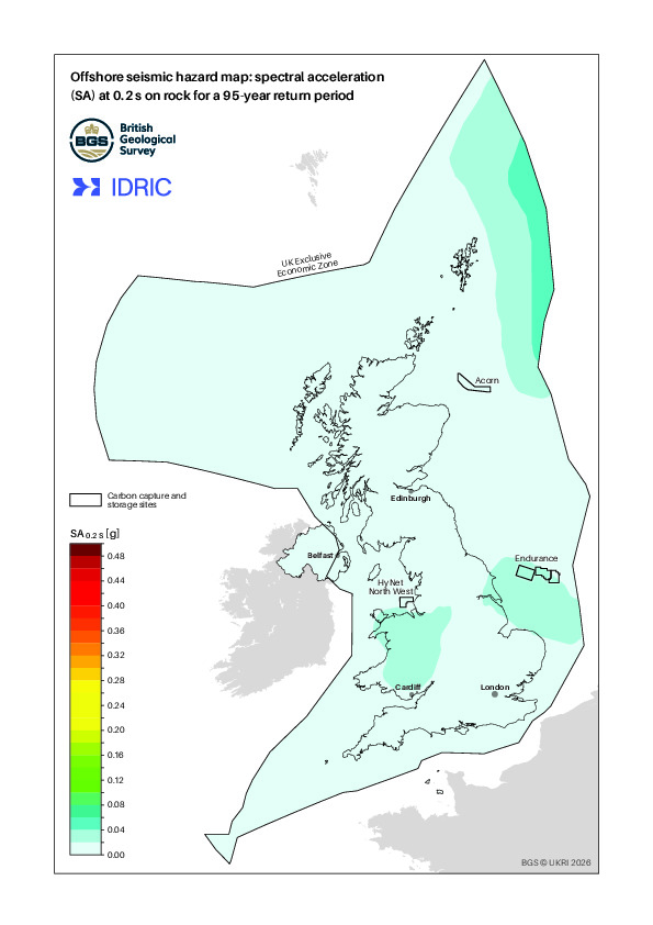
This work provides the 2026 hazard maps for peak ground acceleration and spectral acceleration at 0.15 s (6.66 Hz), 0.2 s (5 Hz) and 1.0 s (1.0 Hz) with 5% damping for the United Kingdom (UK), the Channel Islands, and the UK offshore Exclusive Economic Zone (UK commercial waters), using the 2024 offshore seismic hazard model (Mosca et al., 2024) and a Monte Carlo-based approach for probabilistic seismic hazard assessment. The 2026 maps are estimated for five return periods: 95, 475, 1100, 2475, and 5000 years. These return periods correspond to probabilities of approximately 41%, 10%, 5%, 2%, and 1%, respectively, of exceeding a particular level of ground motion in a 50-year period (the typical service life of a building). For example, for a return period of 475 years, the maps show that the PGA hazard is about 0.04 g for much of the UK offshore EEZ. This can also be described as there being a 10% chance of a particular location experiencing a PGA value higher than 0.04 g in any 50-year time period. The 2026 hazard maps update the 2020 national hazard maps (Mosca et al., 2022) and the 2024 offshore hazard maps (Mosca et al., 2024).
Overall, the 2026 hazard maps confirm that seismic hazard in and around the UK is generally low by worldwide hazard standards and increases slightly in regions of higher observed seismic activity, such as North Wales, the Welsh Marches, the northern North Sea, and the southern North Sea around the Dogger Bank area, where the largest (5.9 Mw) instrumentally recorded earthquake occurred.
The technical report describing the development of the maps, and the data files containing the main elements of the model and key datasets, are below.
Please note that these hazard maps are not a substitute for a site-specific hazard assessment should one be required. The user must take responsibility for checking that use of the results contained in this report is appropriate for the case in question.
The files of the 2024 seismic hazard model are available via the National Geophysical Data Centre HERE. Please cite this data using the following reference:
Mosca, I., Baptie, B., Haslam, R., Gafeira, J., Jenkins, G. (2025). Offshore seismic hazard models and maps for the UK Exclusive Economic Zone. NERC EDS National Geoscience Data Centre. (Dataset). https://doi.org/10.5285/a6babafa-5c82-4e76-aef5-27441104187f.
The output text files of the 2026 seismic hazard maps will be available soon via the National Geophysical Data Centre.
Seismic hazard maps