
Damage from the Haiti earthquake viewed from above
These images show satellite imagery from (GeoEye), provided to Google of the area around Port-au-Prince before and after the devastating earthquake of 12 January 2010.
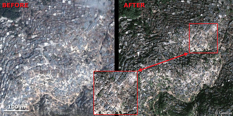
The first image shows dwellings on steep ridges south-west of Port-au-Prince, in the Bolosse area. The image on the left was taken before the earthquake, the one on the right, immediately afterwards.
Houses on north side of ridges more damaged than those on south
Two ridges running roughly east-west are densely packed with houses. Those on the north side of the ridge appear unharmed, but it is clear that many houses on the southern sides have collapsed; the blue-grey roofs are replaced by light colour indicating rubble.
It is not clear from these images why the southern slopes were worst affected. They may be more vulnerable, or it may reflect irregularities in the seismic shaking.
Cathedral in Port-au-Prince destroyed
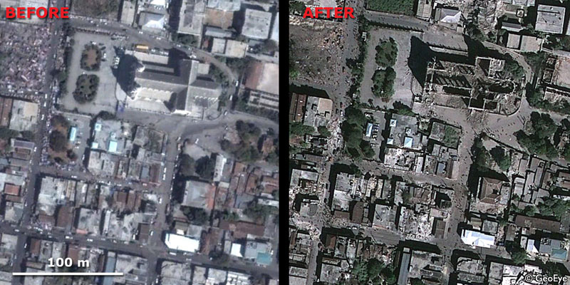
The second image shows the dramatic damage to the cathedral in Port-au-Prince, which has been destroyed. The walls are still standing, but the roof has gone completely. Look carefully at the way the shadows of the arches can be seen on the floor of the nave. To the south-west one can see rubble from damaged buildings blocking the streets, as people mill around on foot - traffic is non-existent.
The rapid provision of imagery like this is of enormous benefit to rescue workers, as the worst affected areas can quickly be identified.
- A Comparison of the Folkestone and Market Rasen Earthquakes
- Seismogenesis and State of Stress in the UK
- Monitoring Volcanic Eruptions Using Interferometry
- Particular events
- Are yesterday's earthquakes tomorrow's disasters?
- Creating 'virtual seismometers' deep inside the Earth
- Is earthquake activity related to the Moon or Sun?
- Is earthquake activity increasing?